-
Publications:
- Kim, K. H., Liu, Z., Rodell, M., Beaudoing, H., Massoud, E., Kitchens, J., Dudek, M., Saylor, P., Corcoran, F., & Reager, J. T. (2021).
An Evaluation of Remotely Sensed and In Situ Data Sufficiency for SGMA‐Scale Groundwater Studies in the Central Valley, California.
JAWRA Journal of the American Water Resources Association, 1752-1688.12898.
https://doi.org/10.1111/1752-1688.12898
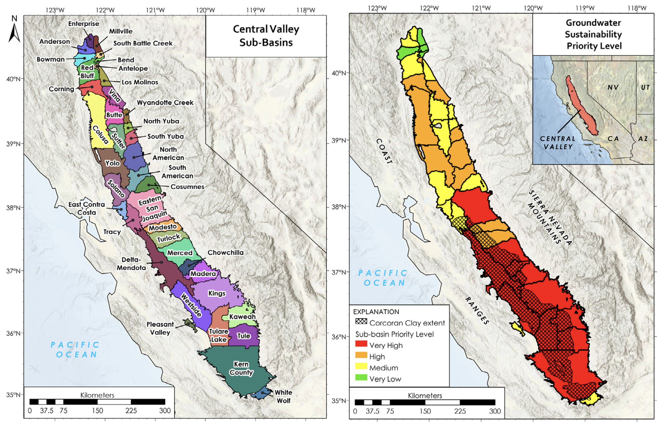
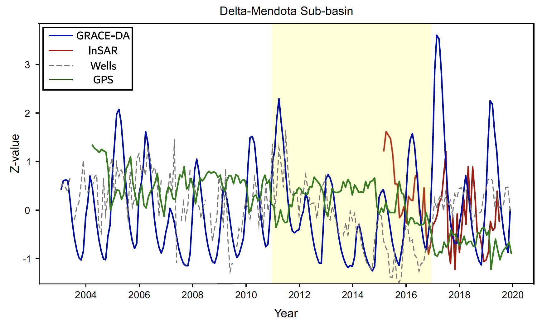
ABSTRACTCalifornia’s Central Valley aquifer is a critical freshwater resource for the state, providing drinking water to 6.5 million residents and irrigation water for more than half of the nation’s produce. Increasing demands have led to a steady decline of aquifer water levels, leading to irreversible compaction and land subsidence. The Sustainable Groundwater Management Act of California (SGMA), instituted in 2014, requires high‐priority regions to establish sustainability plans by 2020–2022 that mitigate groundwater depletion and land subsidence. Many regions within the Central Valley lack groundwater monitoring wells or continuous well data, rendering in situ monitoring challenging. When combined with other data, National Aeronautics and Space Administration’s Gravity Recovery and Climate Experiment (GRACE) and GRACE Follow‐On missions provide valuable information about groundwater storage changes at a subbasin scale. Interferometric Synthetic Aperture Radar measurements can map land subsidence, and Global Positioning System can be used to estimate crustal uplift. Yet, all of these measurements have differences in resolution, coverage, discretization, and record length. Here we assess the various datasets that are potentially useful for Central Valley subbasin groundwater monitoring and provide an analysis of gaps and other issues in regard to their suitability for SGMA related analysis. Finally, we offer the next steps and recommendations on data treatment and integration.
- Corcoran, F., and Christopher E. P. (2021).
Diffuse Attenuation Coefficient (Kd) from ICESat-2 ATLAS Spaceborne Lidar Using Random-Forest Regression.
Photogrammetric Engineering & Remote Sensing 87 (11), 831–40.
https://doi.org/10.14358/PERS.21-00013R2
ABSTRACTThis study investigates a new method for measuring waterturbidity—specifically, the diffuse attenuation coefficient of downwelling irradiance Kd—using data from a spaceborne, green-wavelength lidar aboard the National Aeronautics and Space Administration’s ICESat-2 satellite. The method enables us to fill nearshore data voids in existing Kd data sets and provides a more direct measurement approach than methods based on passive multispectral satellite imagery. Furthermore, in contrast to other lidar-based methods, it does not rely on extensive signal processing or the availability of the system impulse response function, and it is designed to be applied globally rather than at a specific geographic location. The model was tested using Kd measurements from the National Oceanic and Atmospheric Administration’s Visible Infrared Imaging Radiometer Suite sensor at 94 coastal sites spanning the globe, with Kd values ranging from 0.05 to 3.6 m−1. The results demonstrate the efficacy of the approach and serve as a benchmark for future machine learning regression studies of turbidity using ICESat-2.
- Luhrmann, F., Park, J., Wong, W.K., Corcoran, F., & Lewis, C. (2022).
Detecting Traveling Ionospheric Disturbances with LSTM Based Anomaly Detection
35th International Technical Meeting of the Satellite Division of The Institute of Navigation
https://doi.org/10.33012/2022.18343
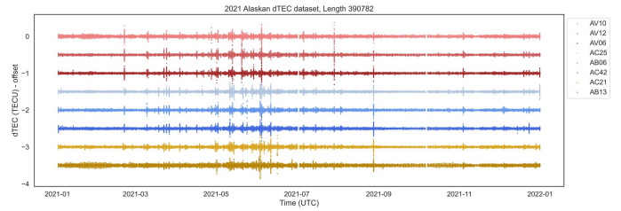
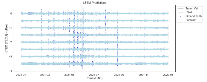
ABSTRACTLarge natural hazards have been shown to induce traveling ionospheric disturbances (TIDs) caused by the acoustic, acousticgravity, and gravity waves produced from these events. These induced TIDs are observable in the total electron content (TEC) measures from dual-frequency GNSS receivers. Previous research has focused on methods to detect an event on a specific day. This research expands this objective to detect an event from an entire year of slant TEC (sTEC) data. There are several challenges of detecting a natural hazard induced TID across an entire year due to variations of day-to-day and seasonal ionospheric activity, and scintillation due to unknown sources. This work proposes the application of a deep learning neural network, specifically a long short term memory (LSTM) neural network, combined with statistical analysis, to detect TIDs from detrended sTEC (dTEC) for the year 2021 from stations along the Alaskan peninsula and islands. The LSTM is a type of recurrent neural network (RNN) that outputs future dTEC predictions from past dTEC values. TID detections rely on errors calculated as the difference between ground truth observations and the LSTM predictions. These errors are filtered using a rolling mean error threshold to remove moderate to minor errors, as large errors indicate a significant and sudden change in the dTEC data as expected at the start of a TID induced by a significant natural hazard. Station dTEC on dates with large errors detected are then checked for moderate to strong cross-correlation with other stations. Date and times that show an overlap between a pair of stations with large errors and moderate to high correlation at the time of the error (i.e., show phase synchrony) are determined to be an ionospheric anomaly and potential TID. This research work serves as a new method of TID detection for the broader fields of natural hazard detection and ionospheric monitoring.